Chile

Pass the pepper: Crossing Bolivia's Uyuni salt flat

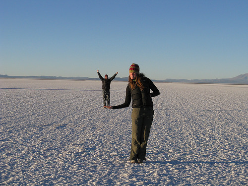
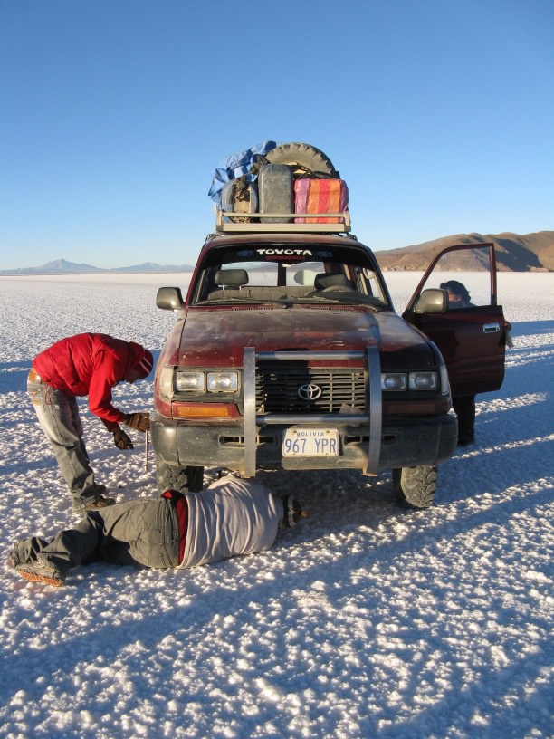
Our jeep barreled for an entire day across the infinite nothingness of the Salar de Uyuni, the largest salt flat in the world. For six hours straight, we saw salt, we saw sky, and that’s about it. The salar is 4,633 square miles of packed salt that measures an average of 23 feet thick. It’s what remains of the prehistoric Lago Minchin, which once covered the majority of southwest Bolivia. It’s an illusion-inducing landscape that plays tricks on the mind, and it’s like nothing I’ve ever seen before.

We discovered people become really small on the Salar de Uyuni

And that doing ordinary things becomes much more fun

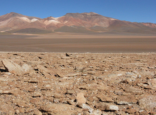
Our three-day jeep trip took us from the Chilean desert town of San Pedro de Atacama to the Bolivian valley village of Tupiza. We crossed from the border during the first ten minutes of the trip, then proceeded through the baked red Bolivian desert, where geysers boil and steam, and lakes take on colors other than blue.

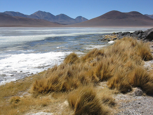
The Bolivian desert

Lago Blanco, with waves frozen in place

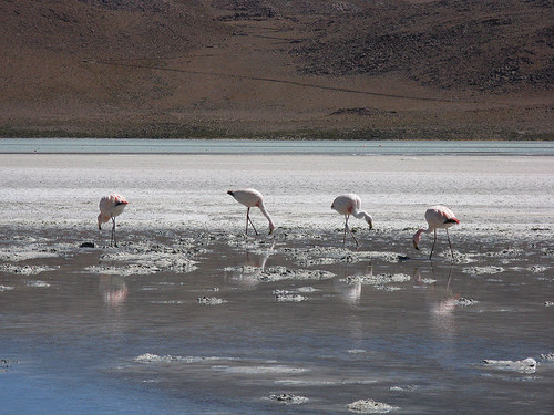
Flamingos wade knee-deep in many of the lakes, filtering for microorganisms

The deserts’ elevation ranges between 12,000 and 15,000 feet above sea level. It’s extremity caused us to become short of breath every time we walked uphill and scramble for hats, gloves and extra layers every time got out of the jeep door to walk around outside.

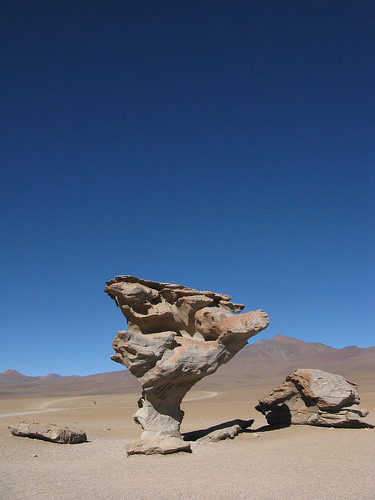
The rock tree, one of many rock formations we saw along the way

Simione, our Spanish-speaking driver, was born in a village just a couple hours from the salar and normally spoke the Quechua language native to the region. He stared straight ahead and chewed coca leaves during most of the drive, but at each stop, jumped out to pop the hood, scoot underneath the vehicle or change a tire. At one point, he had to repair the front passenger door, which had been ripped off by the wind.

Simione and another driver operating on our jeep

Laura and me in a tiny town on the edge of the salar, waiting for our drivers to fill the vehicle with gas

We stayed the first night at a modest refuge in the desert and the second at the Salt Hotel, located two minutes from the edge of the salt flat. The hotel is constructed completely from blocks of salt; licking the walls, tables and stools would make you thirsty. Even the floor of the bedrooms and dining room was covered in grains of NaCl.

Two days before our trip, two jeeps traveling toward each other collided on the roadless, wide-open salt flat. The canisters of gas strapped to the roofs of both vehicles exploded, killing all passengers and one driver.

As we passed the accident remains from a distance, we could see the burnt hulls of two 4 x 4s standing out like dark skeletons against their snow-white surroundings. We all realized it could have been us, and the sight was truly sobering.

For more pictures of the trip, click here.

Put down the goggles and step away from the cap

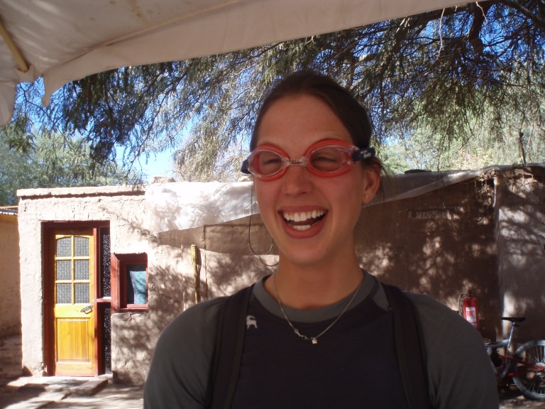
After months of carrying my swim cap and goggles around South America, I have accepted reality: I am not going to need them. I bought the two luxury items in Punta Arenas, Chile last November in preparation for free swim at the city’s public pool. That’s the only time during my eight months in the southern hemisphere I’ve actually been able to use them. With this — and my backpack’s ungodly weight — in mind, I decided to take drastic action: I left my swimming apparel in the room of my hostel in Chile’s Atacama Desert, one of the driest places in the world.

My sister Laura bidding farewell to my prized possessions

I swam competitively through high school and have continued regular trips to the pool in all the places I’ve landed since then. Though my 100-meter freestyle is nowhere as fast as it used to be, swimming continues to be very important in my life. Thus, I did not give up on the dream without a fight. I searched out public pools in every place I visited, but found myself foiled every time.

Here’s the collection of excuses that finally defeated me:

  • Sorry, the pool’s empty for its holiday cleaning. Try back in January!
  • The pool is only open on weekends. Sucks for you it’s Tuesday.
  • You cannot pass this gate. You are not a member of the club. Go back to your home.
  • You must pay $17 to use this pool for an hour. We need exact change.
  • The pool’s easy to find. Take the red line to the third stop, then the green line to the fourth stop. Walk four blocks north, two blocks east, and you’ll find it in an unmarked building.
  • The pool is five feet long and full of kids on foam noodles. Probably won’t need those goggles.

Alas, I hope someone in the dry, dry Chilean desert has found a use for my cap and goggles. Given their location, it probably won’t be lap swimming.

As a sidenote: We spent a lot of time exploring the arid terrain around the desert oasis town of San Pedro. It’s hard to believe this dry landscape can be found in the same country that boasts the glacier-covered Torres del Paine National Park.

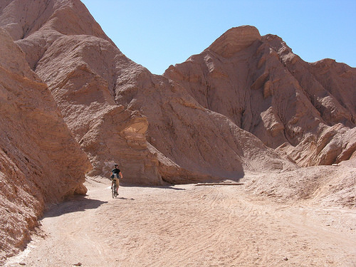
We rode the twisty trail through Quebrada del Diablo, or Devil's Gorge, on mountain bikes on day. Such fun.

Pisco sweet: Three days in Chile's Valle del Elqui

house-in-valley1

The skies over Chile’s Valle del Elqui are clear more than 300 days a year, making it an ideal place to study the stars. During our two days in the valley, Laura and I did just that… sort of.

The guide of the astronomy talk we signed up for led us to a dusty field, set up his telescope and then declared that science, constellations, the cardinal directions and naming things are — and I quote — “stupid.” Needless to say, we didn’t learn much about astronomy. We did, however, manage to see Saturn and its rings and a couple bright stars, I’m not sure which ones.

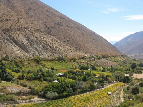
valley-pretty Valle del Elqui stretches the width of Chile, from the northern beach town of La Serena to the Argentenian border. It’s punctuated by little villages that sustain themselves mostly by growing the super-sweet grapes used to make the alcohol pisco, Chile’s national drink.

pisco-bottles

fuegos Labels for the pisco bottles, still on the spool

More than 85 percent of the pisco produced in Chile comes from the valley. On the way in, we toured the family-run Fuegos distillery, where we tasted the grapes and sampled the pre-pisco alcohol, which has an alcohol content of 68.7 percent.

me-on-trailMe, descending

horse-in-desertA horse along the road

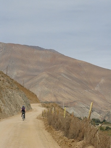
Laura and I fell in love with Valle del Elqui during our time there. On our second day, we rode mountain bikes down the dry dirt road from the far interior town of Alcohuaz to our home base in Pisco Elquis. Along the way, we passed lots of grape vines, a few men on horseback and many dogs too sleepy to bother chasing us. We stopped at the artists’ community outside the village of Horcón, where we wandered among artisans in hammocks and browsed booths filled with medicinal herbs, handmade jewelry and batiked clothing.

Laura and me during our bike ride, wearing protective head gear to prevent injury.

Hiking a hidden valley

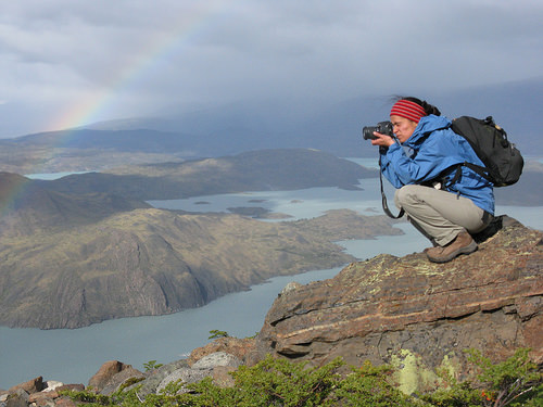
My friend Juliana and I meant to spend a day meandering through Valle Bader, the high-elevation valley that runs between the 7,200-foot slab of the easternmost Cuerno and the 8,700-foot glacier-capped Almirante Nieto. Instead, we ended up scrambling up and down one of the more precarious moraines in the area and almost summiting both peaks. Not bad for a dayhike. Despite the wrong turn five minutes into the hike through the trail-less valley (the RIGHT side of the river, the RIGHT!), we saw some of the most amazing views ever. From the valley’s entrance, we could see numerous lakes, each a different shade of blue, and once inside, we could see the actual base of the cliffs we're so used to seeing from afar. Rainbows arced overhead most of the day, and we saw wild parakeets on the return hike.

on-a-rock-under-a-rainbow.jpg

That's me, squatting low to avoid blowing off the mountain, near the entrance to the valley.

juliana-taking-pic.jpg

That's Juliana. She's taking a photo.

two-lakes.jpg

Lago Nordenskjold and Lago Sarmiento, two of the lakes we could see from up high.

lotsa-lichen.jpg

Nordenskjold again. Pretty.

juliana-entering-valley.jpg

During our hike, it rained, it snowed, the sun beat down on our backs, and the wind blew.

lunch-spot.jpg

This is the Cuerno we almost summited, accidentally.

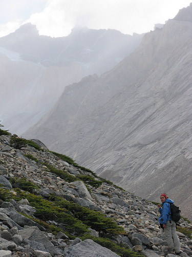
We traversed the top of this moraine — and ate ham sandwiches almost at the base of the Cuerno — before realizing we were probably very far from where we were supposed to be. We decided to walk out on the other side of the valley, where we could make out a faint trail through much safer territory.

Descending the moraine of loose rock was tough. We scooted backwards down the mountainside, placing our hands and feet on the rocks with great care to avoid starting avalanches. We crossed the pounding river at the base of the valley, and in the process of searching for the trail on the other side, almost summited Almirante Nieto.

While we didn't see as much of the valley as we could have if we'd had more time and hadn't climbed so far in the wrong direction, we were blown away by what we did see. Valle Bader is a magical place for sure.

apple.jpg

For more photos of Valle Bader, click here.

Moving on

On my last day of work, I was thrown into a sopping-wet mixture of mud and horseshit. I was at the stables saying good-bye to the baqueanos when they all started chanting “Al barro! Al barro!” (This means “To the mud.”)“Alvaro,” I thought. “Is THAT the name of the new guy who’s been hanging around?” Before I had come to any conclusions, two baqueanos grabbed and carried me into the corral, which had been freshly saturated by the recent rain. They lowered me — by this time, kicking and screaming — into the squishy muck. It promptly soaked through my fleece jacket, T-shirt and pants and onto my skin. For those of you who’ve never lain in a pile of wet shit, it’s very disgusting, and you’re not missing much.

on-the-fence-medium.jpg

They all seemed pretty pleased with themselves, damn them.

All that’s to say, after six months of marketing, a muddy baptism and a much-needed shower, I’m through with work and off to see South America — and hopefully write more than I have been.

While my plans are not well formed, here’s the gist: I’ll do a few hikes in the park and meet my friend Alexis in Buenos Aires, where we’ll stay a couple weeks. Then I’ll fly to Santiago at the end of April to meet my sister Laura. She and I will travel through North Chile, Bolivia, Peru and Ecuador through May and June and then return to the states probably around July 1.

I’m slightly apprehensive about surfacing from the cultural immersion I experienced in Paine, where I was the only foreigner in a 260-person company. For the past six months, I have been completely immersed in the Chilean way of living and working. I’ve spoken mostly Spanish, hung out with mostly Chileans, eaten mostly white bread and lamb and listened mostly to the choppy ch-ch-chhh rhythm of regaetton music.

juliana-in-casa-med.jpg

Juliana cooking lunch in the living room of the house we share with others in Paine

I realize as I embark on my travels, I will no longer be as in touch with the local peoples and places as I have been. I will share bunkrooms with people I don’t know, stand in line to visit must-sees and probably speak more English than Spanish.

While I’m sad for the experience I had in Paine to end, I am also excited about what’s to come. I can’t wait to see the sun set over the desert in Northern Chile, to explore the jungles of Bolivia and to hike five days to Machu Picchu in Peru. I’m excited to talk to locals and hear their stories. I’m looking forward to not knowing what each day will bring and being surprised at every turn.

Madre, padre — meet Chile

My parents’ Spanish came a long way during their visit to Chile this month. My mom can now say “Mucho gusto” with a perfect Chilean accent (context isn’t THAT important, is it?), and my dad can get around pretty well with the word “postre” (“dessert”). During their two weeks here, I introduced them to all the people and places I’ve come to know over the last few months. They met my bosses, friends and self-declared fiances. They hiked to the granite spires that tower over the landscape where I work. They learned to embrace instant coffee and powdered milk with breakfast every morning and become as engrossed in the dramas of the street dogs in town as I am.

Below is a basic description of how we spent our time together. But before I go any further, let me introduce my parents with some visual aids acquired on the trip.

My dad, Barden:

cute-pic-of-dad.jpg

And my mom, Terri:

portrait-of-mom.jpg

W Circuit Ok, so with the schedule modification, it was more of a transposed U, but same thing. On my parents’ SECOND full day in Chile, we started a super-relaxed, two-hour hike (note the key words) from Lago Pehoe to Campamento Italiano. During this walk, we crossed paths with a Russian language professor from New York who delivered the most interesting 45-minute monologue I’ve ever heard. It seamlessly transitioned from the airplane passing overhead to alcohol abuse in Norway to icebergs, and it was peppered with an informative mix of facts and statistics. We listened, mostly, slackjawed and enraptured.

Also during the hike, my mom caught me up on the wolves new to the Natural Science Center where she works, and my dad filled me in on details from the Hillary/Obama race.

We camped by Río Ascencio and ate pasta and red sauce for dinner. My mom shoveled her food with a titanium spork, which she really likes because its Titanium. I don’t really get it. It burns when it gets hot, and that just doesn’t seem practical for an eating utensil.

We ascended to the mirador at the top of the Valle Frances in the morning. We ran into my friend Chapa, who was guiding a Dutch group over rock and root around the 10-day circuit IN HIS CROCS.

tiburon.jpg

El Tiburon, or Shark's Fin, one of many granite monoliths that surrounds you at the top of Valle Frances.

We stayed in one of the seven cabañas near Refugio Los Cuernos. Down comforters, a skylight, a waterfall right outside. What luxury.

My very-macho guardaparque friends at Campamento Italiano near the base of the towers invited my parents and me into their triangular house for dinner. They even used a teacup to mold the rice into cylinders on our plates. We ascended to the towers in the morning.

mom-climbing.jpg

My mother conquering the moraine you have to climb to get to the view. This is when I decided a five-hour hike up Valle Silencio that afternoon was not a good idea.

classic-tower-shot.jpg

The Cookes (minus one) at the top. (Laura, want to photoshop yourself in?)

ADDED LATER:

classic-tower-shot-modified.jpg

I forgot to mention: My sister Laura made it to the towers with us! It was really great to all be together, even if for a short time.

Río Serrano

three-kayaks.jpg

The morning after finishing the hike, we crammed ourselves and our stuff into neoprene and dry bags, respectively, for a three-day kayaking trip on Río Serrano. The river runs 28-miles along the southern border of Torres del Paine National Park and carries water from six ice fields and many more mountain glaciers to the Pacific Ocean. We paddled from its beginning at Pueblito Serrano to Glaciar Serrano, located right where the river empties into the fjords. (“Fjord,” incidentally, is my new favorite word.)

kayak-in-glasses.jpg

Our Turkish guides Cem and Serkan both knew pretty much everything there is to know about everything— and were kick-ass cooks to boot.

During our first 45 minutes in the kayak, we faced winds so forceful they blew the river upstream. This is not normal, given that rivers normally flow downstream. I did my best to dig my paddle into the whitecaps and ferry from one shore to the other, all the while getting sprayed in the face with airborne water. Our guides said the wind around here often blows around 50 mph and sometimes reaches around 100. In the United States, that’s considered hurricane force, and it blows houses down. In Chile, you keep paddling.
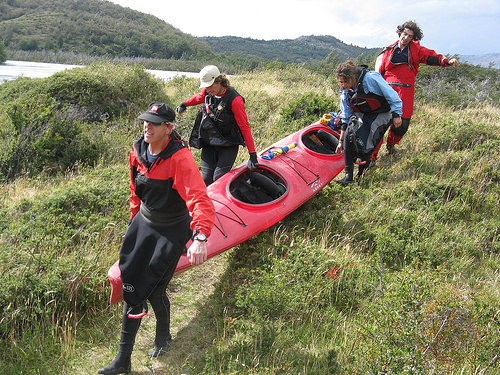
karrying-kayak-pic.jpg

We decided it best not to run the pounding waterfall in our sea kayaks. Instead, we carried our stuff around.

My father flipped while ferrying across the river at the base of the waterfall. The guides rescued him from the glacial water.

Though we faced strong winds continuously throughout the journey, nothing was on par with our initiation. The river was swift but calm as it wound through lenga forests and beneath dark, imposing mountains. We saw a number of tremendous, age-old glaciers creeping imperceptibly down mountainsides, still at work shaping the landscape.

We ran into virtually nobody else during the whole journey, probably because no roads or trails cut through the Serrano sector of Torres del Paine. We had the whole area — the water, the wind, the glaciers, the forests of lenga trees covered in lichen — to ourselves. I felt privileged.

At one point, we passed several log structures built by a hermit who has not left the river’s bank in the 12 years since he lost a woman to his cousin. I was dying to stop and talk to him, but we continued downstream. Our last night, we camped by Glaciar Serrano, which measures about 75 feet high at the point it touches the river (that’s the visible part). We kayaked as close as we could to the glacier’s base in the morning.
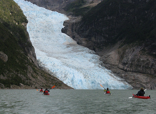
approaching-glacier-in-kayak.jpg

extraterrestrial-lichen.jpg

Otherworldly lichen we ran across in the glacial moraine

We took the 21 de Mayo ferry through the fjords from the end of Río Serrano to Puerto Natales.

bag-head-photo.jpg

A man on the boat wore a plastic bag on his head. I have no idea why. But it fluttered in the wind as he gazed out over the bow, and it was hilarious.

Cueva del Milodon
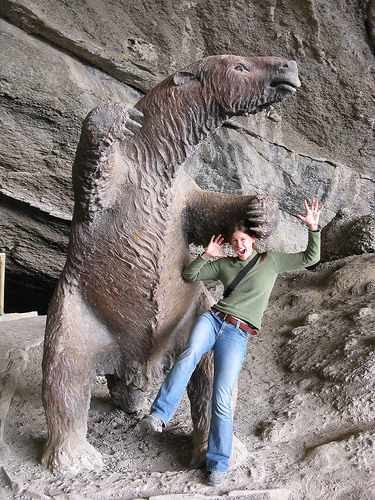
milodon-and-me.jpg

I almost got eaten by a lifesize replica of the giant ground sloth in the Cueva del Milodon.

In 1895, scientist Otto Nordenskjold discovered the skin of the giant Milodon sloth in a massive cave 25 km north of Puerto Natales. The Milodon, which stood about 20 feet tall, went extinct 8,000 to 10,000 years ago when the roots it gummed for sustenance stopped providing the nutrients it needed for survival. At the national monument, you can into and around the cave, which measures 656 feet deep, 98 feet high and 262 feet wide and looks a lot like the moon inside. There are a couple other caves you can visit at the monument as well, but we didn’t get to those because the taxi driver who carried us would only wait an hour.

Río Verde

rio-verde-basking.jpg

Río Verde basking in the sunlight, Otway Sound in the background

My mom, dad and I ran through the pasture at Río Verde, waving our arms, yelling, and otherwise trying to convince a herd of 100 sheep to take the most direct route between the corral and the green seaside pasture. We were helping my second cousin Christian Santelices (also an international climbing guide) manage the animals on his family’s ranch outside Punta Arenas. The majority of the sheep followed our breathless commands, though eight accidentally separated from their compatriots, got extremely confused and took off for the other side of the pasture. Seeing fleecy butts run off toward the horizon is frustrating, but it’s extremely cute at the same time, so you can’t be too upset.

sheep-in-the-barn.jpg

Most of what we ate during our visit to Río Verde grew up within a mile of our table. The lamb, the lettuce, the eggs: all completely fresh and extremely tasty. Wish I could eat such high quality food all the time. Check out Christian's wife Sue's website on ecogastronomy.

hands-beans.jpg We picked and shelled peas from the family’s garden, then ate them for dinner.

Punta Arenas

penguin-rock-pic.jpg

The penguins on Isla Magdalena, off the coast of Punta Arenas.

We understood our tour guide to say that the chief predator of the penguin is — get this: the squirrel. As might be expected, this drove my mother and me into uncontrollable hysterics. We misheard, I'm sure, though it would be much more fun if we didn't.

tombs.jpg

graveyard-reflections.jpg

We stopped by the cemetery one afternoon in Punta Arenas to explore the ornately decorated tombs. Macabre, sí, but worth the visit.

To see more photos of our trip, click here.

A pitch black night and golden morning

From treeline on Cerro Paine, the lunar eclipse Wednesday night was spectacular. After hiking up the sandy mountain in the dark, we pitched our tents on the only slivers of flatness we could find. Then we sat beneath the lenga trees and polished off a box of wine and loaf of marble cake while watching the moon change from a burnt orange globe to nothing to a burnt orange globe again (the pics didn’t do it justice). The wind was too powerful in the morning to ascend an hour and a half to the top of the mountain for sunrise (Gabriel guessed the gusts were 200 mph at the summit), so we just walked a few minutes up from our campsite to a clearing. And, Oh. My. Goodness. For 15 minutes as the sun was rising, we lived in the most golden world I’ve ever seen. The entire landscape, including the towers in the distance, was illuminated. We glowed, so did everything else, and above it all shone a rainbow.

towers-at-sunrise.jpg

Come on, be a nice horsie: The Chilean jiniteada

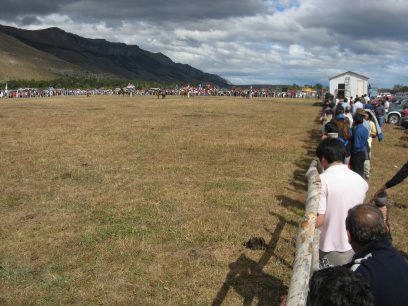
I’ve spent the last two weekends watching my baqueano friends jinetear (hi-ni-tay-ar), which, translated directly, means “to show off one’s mad horsemanship skills.” I went to a local jineteada Feb. 1, 2 and 3 in the town of Cerro Castillo (pop. 100) and an international one the 8 and 9 at the Estancia San Jorge, located about 12 km outside Puerto Natales.

jin-dark.jpgThe playing field in Cerro Castillo

san-jorge-field-pic.jpgAaaaaaand... in San Jorge

Jineteadas are the same as rodeos, only different. During the main event, participants try their damndest to stay planted on the back of a bucking animal that flatly rejects the idea of being ridden. In a rodeo, the main event involves a bull with its balls tied; In a jineteada, the main event involves an untamed horse, upset by the events that proceed as follows:

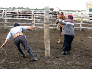
1. In a muddy corral at the end of the jineteada field, baqueanos rope the wild horses one at a time, then shimmy bridles over their noses. Sort of like face bras. Nobody likes that.

bridle-on-real-pic.jpg

2. Just before the event begins, someone runs the horses from the corral to the far side of the field, where they tie them to one of three 15-foot posts. A bleacher full of spectators looks on. The horse sometimes protests by bucking, yanking away or lying down. The baqueano manning the post fastens a leather strap around the horse’s midsection. In the case of the basto event, this will be the only item the rider has to hold onto.

hate-this-pole.jpg"No."

3. The rider, with a little help from his friends, mounts the horse. He wears sharp spurs around his boots.

4. An official on horseback approaches the post, raises a flag, then lowers it. In a split second, the baqueano in charge of the post releases the rope tying the horse to the pole. The rider kicks the horse with his spurs, slaps it on the butt with his whip, and the horse takes off, his head lowered, his feet kicking. The rider holds on for his dear, dear life until the gong sounds after eight, 12 or 15 seconds, depending on the event.

whoa-nelly-pic.jpg Sometimes this is incredibly graceful. The horse bucks and the rider’s body follows its rhythm, staying strongly anchored to its back.

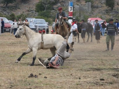
big-buck-pic.jpg Other times, it is incredibly not graceful, like when a wild buck sends the rider crashing to the ground, where, if his foot does not slip properly out of the stirrup, he gets dragged and trampled as the horse sprints across the field toward the corral. I cringed through this during the Cerro Castillo jineteada. An ambulance is always parked right outside the field for this occasion.

nasty-fall-pic.jpgNot a fall that required an ambulance, but painful to watch nonetheless

A couple of the baqueanos who work at the hotel participated in the jineteadas this year and both won first place at their events.

While the international jineteada at the San Jorge ranch focused completely on riding wild horses, the Cerro Castillo event encompassed a few other competitions as well. Kiddies rode sheep, teenagers rode cows, baqueanos lassoed the front feet of horses and brought them to the ground.

riding-sheep.jpg lassooooooooooo.jpgOne of the most popular events at the jineteadas, however, was the never-ending fiesta. Most everyone was a contestant — and most everyone a winner.

I joined the game late in Cerro Castillo, attending an asado, or cookout, in the fenced-in patio of a Castillo resident after the day’s events finished up. We grilled lamb over an open fire while a local guide/musician nicknamed Chapas played traditional music on his guitar, accompanied by many voices and a makeshift drum.

grilling-out-pic.jpgCarlitos and William tending the meat

paola-on-drum-pic.jpgPaola on drums

Meanwhile, we slang back (new term, invented for the occasion) beer and Piscola (the Chilean liquor Pisco mixed with Coke).

Around midnight, we headed to a dance in the school gym, a la 7th grade. A live band, a packed basketball court, aerobic dancing and tons of fun. Eventually required a sweatband on my part.

We CAN stop the fire

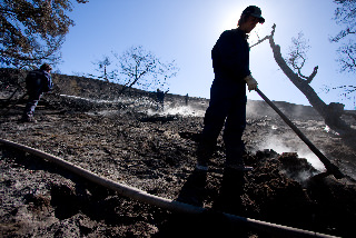
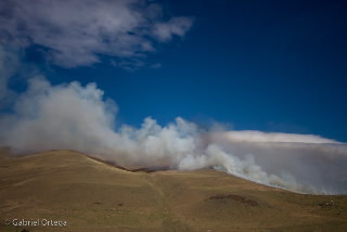
gortega_incendio24.jpg No need to fight anymore, the fire’s just about out. The volunteers that battled the blaze near Laguna Azul on Wednesday say everything is under control. The brigade cooled the burning topsoil and roots by digging open the earth and pouring water on the ground. As they worked, they saw clouds of smoke rise from the soil and the water they poured begin to boil. Hot work, but well worth it.

Photo by Gabriel Ortega. All rights reserved.

Danger, danger! The park is on fuego!

The meter at the forest service’s Laguna Amarga outpost called it right when rating the fire danger “extreme” yesterday. Since mid-afternoon, clouds of thick gray and black smoke have risen from the pampa near Laguna Azul, about 10 km from where I’m based at Refugio Torre Central. As of now, no one’s sure how the fire started. fire-1.jpg

fire-4.jpg

My friend and coworker Gabriel Ortega headed out to see the fire around 4:30 this afternoon and took a few shots while he was at it.

Brigadeers from the nearby town of Rio Turbio in Argentina have been fighting the blaze for most of the day and say they have it mostly under control. Still, the hot, dry weather over the last two weeks has left most of the grass around here a brittle brown, and the wind has been blowing hard all day. Not a good combo.

fire-2.jpg

Uncontrolled wildfires have destroyed parts of the park several times before — most recently in February 2005, when a hiker’s lit campstove overturned in an area where fires where prohibited. The resulting flames singed about 5 percent of the park — 28,083 of the park’s 598,500 acres, 37,602 acres total. The hostería Las Torres is assembling a team of volunteers to fight the fire starting Wednesday. The group will head out at 8 a.m. with shovels and buckets, and has been warned not to wear clothing that contains plastic. No pleather pants, people. Suerte!

fire-3.jpg

All rights reserved on the photos.

Where the magic happens

office-fun.jpg

My coworkers and me in the Fantástico Sur office on the second floor of Refugio Torres Central. Milan (back row, higher boy) just brought us some toast from the kitchen downstairs, so we’re all happy.

Everyone stay at refugios run by Fantástico Sur! They’re the best! You’ll be lodged, you’ll be fed, you’ll be happy!!! E-mail reservas@fantasticosur.com, or call our reservations line based in the park at (56)(61) 360-361, extension 380.

Does that count as my marketing for the day? Can I go play outside now?

Go away, invader!

So, I got this article published in the January edition of the Patagonia Black Sheep, a monthly magazine available in Punta Arenas, Puerto Natales and other towns in Patagonia. Yay for getting things published! It's about invasive plants. No, that dandelion is not supposed to be here. And neither is that clover. And that scentless chamomile? An outsider as well. These plant species — and a number of others — made their way to Patagonia years ago and, quite literally, put down roots. Some biologists estimate around 25 percent of the plant species in some parts of Torres del Paine National Park originated elsewhere. “Invasive species are going to continue arriving as a consequence of tourism,” said botanist Osvaldo Vidal, author of the guide Flora Torres del Paine and a doctoral student in Germany, speaking in Spanish. “This is clear.”

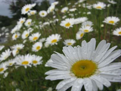
flowah.jpg

Scentless chamomile: Cute, but invasive

Many of the invasive grasses and ground covers found in Patagonia were introduced as forage for livestock, and many of the flowers were brought over for ornamentation purposes. Other plants arrived by accident: Their seeds rode into the region in the fur, feathers or intestines of animals, or the shoes, clothing, tents or cars of humans. Most came from Europe. Some of the most common invasive species in Torres del Paine today are: • Poison hemlock • Red sorrel • Scentless chamomile • Silver hairgrass • Spotted catsear Invasive plants have earned a bad reputation in the scientific community for their tendency to change ecological patterns and displace their native counterparts. Few, if any, studies have been conducted to determine the effects of the invaders in Patagonia, however. Morty Ortega, a professor at the University of Connecticut who has conducted research in the park since 1977, said he considers most of the invasive grasses and ground covers in Patagonia more useful than threatening. “Perhaps the most dangerous ones are those that are brought as ornamentals and escape because of their aggressive nature,” he said, citing a fast-spreading, white-flowered plant named cicuta as a prime example. He described the plant as both poisonous and useless. Human visitors, hikers especially, are the single greatest threat to the native Patagonian ecosystem today, Vidal and Ortega agree. In addition to unknowingly spreading seeds, they compact the soil, making it ill suited for fragile native species and ideal for hearty invaders. So as you trek through Torres del Paine National Park this season, do your part to slow the invasion. Stay on established campsites and trails, and wash seeds from your clothes and supplies before you arrive and after you leave. That way, Patagonia can stay Patagonia, and stop evolving into the countryside outside your hometown.